
A unique exhibition revealing how young people see the world was recently launched by academics from Northumbria.

They asked young people to create their own maps of Newcastle and Gateshead, but instead of using GPS or digital software they simply handed out pens, pencils and paper. The response was a unique atlas of hand-drawn maps. Gone are the historic monuments and buildings (unless they are useful places to meet friends) and the amenities used by adults are mostly overlooked too. What is revealed, is the importance of friends and families over places or landmarks, and the significance of schools and colleges – past, present and future – as places of memory, friendship, legend, and, of course, dread. The journeys young people take through the city also come through strongly – links between school and home, parents, grandparents and friends, as well as their favourite park, café or cornershop are all significant. Finally, fantasy worlds hidden below the streets, above the buildings and online, pour from felt tips on to paper. These are all worlds occupied by young people, but places traditional maps are unable to represent, and adults struggle to comprehend.

Jon said: “The Mapping the City exhibition was the culmination of over a year of work with young people from around the region. It launched an atlas of maps made by young people, and by us, which illustrate the very different Newcastle-Gatesheads they experience.The year-long project, supported by the Juice Festival, extended from research carried out by Jon, Mike and Sebastian into the positive impact of young skaters on the urban environment.

“Maps are a powerful tool for communicating how cities are and might be, and the maps in this exhibition and atlas are rich with versions of our city missing from authorised cartographies. We hope visitors will better understand what is missing from official maps, and what might be gained by listening more to the city’s young people.”
Northumbria’s Geography and Architecture and Built Environment departments offer a range of courses for anyone interested in these subject areas. Come along to our next Open Day on 26 November to find out more.
Discover More: www.mappingthecity.net
Latest News and Features

Recognition for researcher dedicated to tackling food insecurity in the UK
A Northumbria University academic who has played a key role in bringing breakfast clubs and…
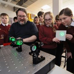
University partnership brings space research to life for school pupils
A North East school has partnered with solar and space physics experts from Northumbria University…
.png?modified=20250916102106)
Telescope reveals surprising secrets in Jupiter's northern lights
An international team of scientists, led by a PhD researcher from Northumbria University, has…
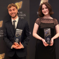
Northumbria Film graduates receive Royal Television Society honours
Two Northumbria University Film graduates have won Royal Television Society (RTS) Student Awards…

Scientists reveal the best and worst-case scenarios for a warming Antarctica
A new analysis of decades of research on the Antarctic Peninsula, involving experts from Northumbria…

PhD student maps mysterious upper atmosphere of Uranus for the first time
A Northumbria University PhD student has led an international team of astronomers in creating…
Developing technology to help empower young innovators across the globe
Northumbria University researchers have joined forces with the International Federation of…

Working-class roots drive North East graduate’s AI healthcare revolution
A Northumbria University graduate has developed groundbreaking AI technology that could save…
More events
Upcoming events
Launch of the Northern Interprofessional Education Strategy
Northumbria University
-
