Skip navigation

Q&A with Professor Adrian Jenkins of Northumbria University’s Cold and Palaeo Environments research group

22nd October 2021

What led to your interest in the interaction between ice and the ocean?

When I first joined British Antarctic Survey in 1985, I was tasked with setting up and resurveying a series of sites extending across the Ronne Ice Shelf, covering roughly the distance from London up to John O’Groats.

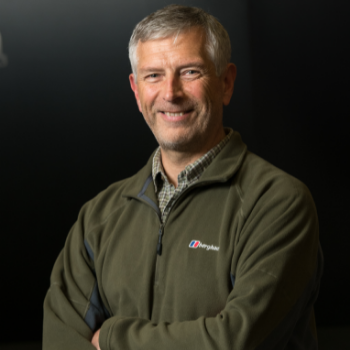
Professor Adrian Jenkins of Northumbria University’s Cold and Palaeo Environments research group

The study took three years. Together with a guide, we worked alone on the ice shelf for almost three months each year undertaking the surveys. I used the measurements to work out the amount of ice that was melting from the underside of the ice shelf into the ocean, or that was freezing onto the ice base from the ocean and found a pattern.

I found that there was rapid melting near where the ice first went afloat, followed by a region of freezing, then a transition back to rapid melting near the ice front. Although that pattern is now universally accepted as what you should see on an ice shelf like Ronne, at the time it was questioned by some people.

So, I started looking into theories for the circulation of the ocean beneath the ice shelf and created a simple numerical model that could explain the distribution of melting and freezing. From that point on I was hooked the challenge of understanding what happens in that unseen world beneath the ice.   


Can you share any memorable tales from your field work in the Antarctic region?

There were some particularly memorable times during my early fieldwork on Ronne Ice Shelf. The usual route to the field operations centre at Rothera Station involved being dropped by ship at a hut partway down the Antarctic Peninsula and being flown the rest of the way.

At the start of my first season, before we got on the ship, all three planes that could have taken us were damaged in a storm and were awaiting spare parts. Getting spares is no easy task when you are a thousand miles away from the nearest civilisation in South America.

The ship, RRS John Biscoe, tried to get us all the way to Rothera but got stuck in pack ice. We drifted for a week, during which time another ship came and unsuccessfully attempted to free us, and we were in real danger of the ship running aground on some nearby islands. Finally, the decision was taken to abandon ship, so we all crossed the ice onto the rescue ship and were taken to the US Palmer Station.

A few days later, one of the aircraft had been repaired and I was flown to Rothera Station. In the meantime, a powerful German ship, Polarstern, had got the Biscoe out of the ice and dropped our gear back at the hut, from where it was eventually flown on to Rothera. I finally began my fieldwork on 4 January 1986, having left the UK on 11 October 1985!

The following season I planned to set up the final sites near the ice front, travel all the way to the grounding line, then travel back to the ice front resurveying everything. But the weather was too poor to fly for long periods of time between the sites. In the end we spent 11 weeks in the field and only managed to get 10 days of work done.

Towards the end of my third season there, a big storm hit the Peninsula, leaving two of the three planes unusable. All the field parties had to be recovered from their varied locations by just one plane. Shortly after our pick-up another big storm came in. We could no longer land at the hut we were heading for, so we had to land on the top of the Peninsula and quickly set up camp before the storm hit. We were stuck there for four days with the only working plane!

When the weather finally cleared the plane couldn’t fly. Its battery was too cold to start the engine. We had to take it out and warm it over a stove in the tent before we could take off. By the time we got to hut it was so dark that the people there had to mark the ski-way with paraffin lamps so that we could land safely.


What has been your biggest research achievement, and why?

A 2009 cruise on the US ship Nathaniel B Palmer to Pine Island Glacier was certainly a career highlight. The floating ice shelf that Pine Island Glacier flows into was known to be thinning, allowing the glacier to speed up, and contribute more to sea level than any other Antarctic outlet glacier.

We spent two weeks in front of Pine Island Glacier sending an Autosub autonomous underwater vehicle beneath the ice shelf on a mission to map underneath the ice shelf.

One of the reasons this was such a highlight is because we had been talking about this since 1989 and this was actually the fourth attempt at getting measurements beneath an ice shelf. We’d previously tried to get to Pine Island Glacier in 2003, but the start of the cruise had been delayed which meant we couldn’t go near the glacier as we risked our ship being stuck in the sea ice. It was late in the season and the ice was starting to grow so it was too risky, and we also had teething troubles with technical upgrades on the Autosub. An Autosub was even lost on a subsequent mission beneath another ice shelf, so it was a real relief to finally be able to use it as we’d hoped.

We ran a number of missions each lasting up to 24 hours but on the fourth mission something went wrong. The Autosub had become trapped under the ice, becoming stuck in a high underwater crevasse before eventually managing to dive down and find a path that was not blocked by ice. It aborted the mission and returned to the rendezvous point to wait for us to recover it.

But these missions actually revealed something we had never known. The Autosub had discovered and mapped an unknown world that had been hidden beneath the ice shelf.

We’d assumed the seabed was level, based on its depth at the ice front, and at the grounding line. But we now know there’s a ridge rising 300m above the surrounding seabed that extends right across the channel that the ice shelf flows through. The detailed features we mapped on the ridge showed that the glacier had once been grounded all the way up to the crest of the ridge.

Further research meant we were able to date the start of the Glacier’s retreat to the early 1940’s – well before there was satellite coverage in the region.

It is remarkable to think that while the Pacific Ocean became a vast theatre of war, in the far south of the Pacific, a change began in the waters beneath Pine Island Glacier that we only discovered half a century later, and the full consequences of which we are yet to understand.


What attracted you to Northumbria?

I joined Northumbria in January 2020, after 34 years at the British Antarctic Survey. I was attracted by the great research environment that Northumbria has built over the years. The CAPE group, in particular, now has world-leading strength in ice dynamics and climate reconstruction among other areas.

The University continues to put a big emphasis on developing multi-disciplinary research and that gives a sense that we can collectively aspire to addressing the biggest problems of our time. It’s an exciting place to be!


What are you working on at the moment?

My current study is a follow-up to the original cruise made to Pine Island Glacier in 2003 that failed to achieve its aims. We ended up working a long way from the glacier but, in among all the testing of Autosub, we were able to observe where and how the warm water that melts the ice flows towards the ice sheet. Subsequent modelling work suggested that the strength of that warm water inflow was affected by winds.

Two science cruises to the area are being planned. We will deploy a descendant of the original Autosub and leave it there for a year to observe the inflows of warm water. We will also use historical satellite data to improve our knowledge of the ocean circulation in that region in the recent past, and use models and reconstructions of the winds to try to understand the past century of change.

Images taken by Johan Rolandsson.

News and Features

This is the place to find all the latest news releases, feature articles, expert comment, and video and audio clips from Northumbria University

Department of Geography

Geography At Northumbria University Encompasses All Of Our Work In Physical And Human Geography, Environmental Science And Management, Health & Safety, And Disaster Management.

a sign in front of a crowd
+

Northumbria Open Days

Open Days are a great way for you to get a feel of the University, the city of Newcastle upon Tyne and the course(s) you are interested in.

Research at Northumbria
+

Research at Northumbria

Research is the life blood of a University and at Northumbria University we pride ourselves on research that makes a difference; research that has application and affects people's lives.

NU World
+

Explore NU World

Find out what life here is all about. From studying to socialising, term time to downtime, we’ve got it covered.


Latest News and Features

Members of the Common Sense Policy Group at Northumbria University have released a new report with Insights North East which presents cutting-edge evidence on regional public opinion on the future of transport policy in the North East.
All Jumbled Up Report Cover
Digital forensics
Dying mangrove trees in the Maldives
Becca French
Autumn 2024 News
Universities re-affirm strategic partnership for city
Spend to Save Britain
More events

Upcoming events

Undergraduate & Postgraduate Open Day
What is to become of us?
Interior Educators Conference 2024
-

Back to top